Become a Supporting Member to remove this ad and help support the site.
Navigation
Install the app
How to install the app on iOS
Follow along with the video below to see how to install our site as a web app on your home screen.

Note: this_feature_currently_requires_accessing_site_using_safari
More options
You are using an out of date browser. It may not display this or other websites correctly.
You should upgrade or use an alternative browser.
You should upgrade or use an alternative browser.
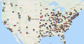
Map of current Division 1 schools
- Thread starter Sycamorefan96
- Start date
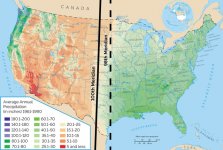
There are so many different charts that create that perfect divide in the United States. It pretty cool to see how D1 schools create another vertical line on the 98th meridian. Like the graft above shows, it all starts and ends with rain fall. Not only for keeping humans/animals alive but it creates tree biodiversity which leads to more/different bugs, which brings in the birds/small critters that get ate up by bigger mammals, and ultimately leads to our dinner plate. It's also interesting how small towns aren't nearly as abundant as they are in the eastern side of the US. The West essentially has to live in cities to be able to tap into natural resources (Las Vegas, Salt Lake City, Bozeman, etc.). You won't meet too many people from a small town in Wyoming, New Mexico, Utah.


